Today:
Skies today will stay sunny as winds continue to stay light out of the North. Temperatures will warm a bit closer to 90 and humidity levels will start to creep up late in the day.
Tonight:
Lows will be pleasant tonight with 50s in the suburbs and mid 60s in the city. Skies will stay clear as humidity levels continue to slowly rise.
Saturday through Tuesday:
The furnace will be turned back on as temperatures climb into the low to mid 90s. A few isolated storms will be possible Saturday night through Sunday night. Sunday looks even warmer with heat indicies climbing to near 100. Independence Day looks dry with partly sunny skies and highs again in the low 90s. Tuesday is dry as well with highs continuing to stay near 90. We badly need rain but the next widespread chance doesn't move in until next Thursday.

Forecast for June 30, 2011
Today:
Gorgeous sums up today nicely. Highs will be in the mid 80s with a light breeze coming from the northwest. It will be sunny throughout.
Tonight:
Perfect patio weather will continue this evening as temperatures drop down to the mid 60s. Winds will be light with clear skies as high pressure dominates.
Friday through Monday:
Friday will be pleasant with sunny skies and temps back into the mid 80s but humidity levels will start to increase again. Saturday and Sunday will be downright hot with temperatures feeling like up to 100 degrees at times. Sunday afternoon a few badly needed thunderstorms may fire but chances aren't great. Monday looks dry with highs near 90.
Forecast for June 22, 2011
Today:
Heat and Humidity will plague the Mid-Atlantic once again today. There will be plenty of fuel this afternoon and evening for more scattered thunderstorms, but the storms will not break the humidity. Highs will be near 90 with winds coming from the southwest.
Tonight:
Lows will drop off into the low to mid 70s with shower and thunderstorm chances tapering off during the overnight hours. Winds will be fairly light out of the south southwest.
Thursday through Sunday:
Gradually improving conditions will start moving in as we inch towards the weekend. The humidity and warm temperatures will stay with us through Saturday but it won't be as warm as Monday or Tuesday. An isolated storm is possible Saturday but Sunday appears dry. The pattern of thunderstorm chances each afternoon/evening looks to return next week too.
Forecast for June 21, 2011
Today:
A few lingering showers are possible early in the day and then we'll have a shot at some thunderstorms in the afternoon and evening. Highs today will be near 90 with winds from the south at 5-10 mph.
Tonight:
Showers and storms will continue to stay in the forecast with best chances during the evening. Lows will be in the lower 70s in the city and upper 60s in the suburbs.
Wednesday through Saturday:
Shower and storm chances will continue to be a threat through Friday. The best chance for the area to receive storms will be Wednesday evening. Saturday we'll begin to dry things out with temperatures through the period warming to near 90 each day. Plenty of humidity will be in the area too, aiding in firing those thunderstorms.
Forecast for June 16, 2011
Today:
A warm front will move through late today and unfortunately the below normal temperatures will come to an end. Today will be pleasant but heat and humidity will return during the evening. Showers and storms are likely by this afternoon as highs warm into the mid to upper 70s. Winds will turn to teh south at 5-10mph.
Tonight:
Scattered showers and storms will continue across the area during the evening before tapering off. Winds will stay from the south and low temperatures won't be as cool as the previous couple of nights as skies will be mostly cloudy.
Friday through Monday:
Storm chances will continue on Friday as the heat is turned back on. We'll be in the mid 80s Friday before touching near 90 again on Saturday. Starting off next week we'll have more shower and storm chances with best chances coming Monday.
Forecast for June 15, 2011
Today:
On a scale of 1-10 we'll have a perfect 10 today. Skies will be mainly sunny, we'll have a light and cool breeze from the north and temperatures will top out at 80 as a High Pressure system inches east.
Tonight:
A low pressure system will start pushing east out of Chicago and bring us an increase in clouds through the overnight. A few showers and thunderstorms are possible as we start off Thursday morning. Lows will drop off into the mid 60s in the city and near 60 in the suburbs.
Thursday through Sunday:
Thursday will be cooler with cloudy skies and shower and thunderstorm chances, especially in the afternoon and evening. Thunderstorm chances continue on Friday as temperatures climb back into the middle 80s. Saturday looks dry with partly sunny skies and highs in the upper 80s. Sunday will be warm as well, and we'll be back into the 90s by the middle of next week.
Forecast for June 14, 2011
Today:
Another gorgeous day is on tap for the Mid Atlantic area. Temperatures will be in the upper 70s and winds will bring in a refreshing breeze from the north.
Tonight:
Outside of a stray shower possible late in the afternoon and early in the evening we'll have partly to mostly cloudy conditions tonight. Lows will drop all the way into the upper 50s!
Wednesday through Saturday:
The comfortable temperatures will persist through Friday before warmer air inches back into the Forecast for Saturday and beyond. Showers and thunderstorm chances will increase as we move into Thursday evening and those badly needed rain chances will continue through Saturday with best chances for rain coming Thursday night into Friday.
Forecast for June 9, 2011
Today:
We'll have sunshine and plenty of heat again today. The furnace is fully cranked and we once again have a Heat Advisory in effect until 8pm. Temperatures today will top out near 98 but a 100 degree reading somewhere near the District can't be ruled out. Our record high for June 9th is 102 and that was set back in 1874. Winds will be fairly light out of the west.
Tonight:
Temperatures will only drop down to near 80 as a weak front pushes through. Showers and thunderstorms will be possible in the evening with winds becoming light and variable.
Friday through Monday:
Shower and thunderstorm chances will stay off and on through Sunday. The best chance for widespread activity will be Friday night but a few isolated storms can't be ruled out for the weekend either. I would not reschedule any outdoor plans though as they won't be extended rain producers. Temps on Friday will be in low 90s and then we'll come back into the 80s from Saturday into next week.
Forecast for June 8, 2011
Today:
A Heat Advisory is in effect through this evening. If you are spending an extended period of time outside today make sure you drink extra fluids and wear plenty of sunscreen as it can take less than 15 minutes to burn with the intense sunshine. Highs today will be in the upper 90s.
Tonight:
Temperatures will stay warm this evening as we only drop into the upper 70s. Skies will be mostly clear and winds will be fairly calm out of the west.
Thursday through Sunday:
The intense heat will be with us on Thursday but then begin to subside Friday through Sunday. Friday and Saturday highs will be near 90 and Sunday we'll drop back into the 80s. Chances for showers and thunderstorms are possible Thursday night through Sunday as well, but there won't be any all day storms to speak of.
Forecast for June 6, 2011
Today:
Today temperatures will be right where they should be for early June in DC. Highs will hit the mid 80s. High pressure sits off to our west and will keep our winds light and skies sunny.
Tonight:
Light winds and clear skies will be found across the Eastern Seaboard tonight. Temperatures in DC will cool into the mid 60s while outlying suburbs drop into the upper 50s.
Tuesday through Friday:
The furnace will be kicked back on by Wednesday with temperatures roaring back into the mid to upper 90s. The heat will then stick with us through Friday. Thursday night and Friday we will have chances for showers and thunderstorms. Looking beyond into the weekend it looks dry with temperatures in the mid 80s.
Surface Map:
Forecast for June 2, 2011
Today;
Today will be incredibly refreshing as temperatures only warm into the mid 80s. We'll have much drier air as well with dew points hanging around the 50s. Skies will stay sunny through the day.
Tonight:
We'll once again have a perfect evening to dine outside. Low temperatures tonight will drop to near 60 with clear skies and light winds.
Friday through Monday:
Minus a stray thunderstorm on Saturday afternoon the next several days look completely dry and pleasant. Temperatures will be closer to their seasonal norms (Mid 80s) with mainly sunny skies.
Storm Reports from June 1, 2011 Storms:
Forecast for June 1, 2011
Today:
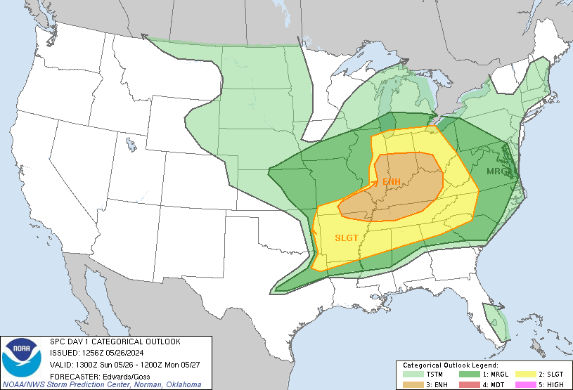
A Heat Advisory will remain in effect through this evening as the oppressive heat will continue one last day. High temperatures will be in the mid 90s with winds coming from the WSW at 5-10 mph. Some thunderstorms are possible in the afternoon as a front moves through. They may be severe with damaging winds being the main threat. Hear is the latest severe threat from the Storm Prediction Center in Norman, OK:
Tonight:
The chances for severe weather will continue during the evening before humidity levels drop and we cool to a temperature in the upper 60s. Winds will be light from the southwest.
Thursday through Sunday:
We will be dry from Thursday through Sunday and temperatures will be more like early June than mid July. Highs Thursday and Friday will be in the low to mid 80s with temperatures warming to near 90 for Saturday and Sunday.
Flier:

Subscribe to:
Posts (Atom)