Today:
An isolated shower or storm is possible today but most areas will be dry. Temperatures will warm into the low to mid 80s underneath mostly sunny skies. Winds will be from the west at 5-10 mph.
Tonight:
An isolated storm is possible in the evening as the region cools off into the mid 60s. Winds will be calm.
Tuesday through Friday:
Anticipate mainly dry conditions through the week, which is exactly what our ground needs. Temperatures will be in the mid 80s Tuesday/Wednesday before a cold front really cools things off. Highs Thursday and Friday will be near 70 degrees!

Forecast for September 8, 2011
Today:
Another wet day is likely for the Mid-Atlantic and Northeastern portion of the country. Pennsylvania and sites just to the north of DC are seeing record flooding and no more rain is needed. Highs today will remain fairly seasonable in the upper 70s with spots to the south (Williamsburg) reaching the 80s. Rain showers and thunderstorms will be the heaviest during the afternoon.
Tonight:
More rain with isolated thunderstorms will fall during the nighttime hours. Lows will be in the low 70s as the humidity across the area remains. Winds will be light out of the east.
Friday through Monday:
Shower and storm chances will be in the forecast each day but Friday night and most of the day Saturday should remain dry. High temperatures through the period will be in the low to mid 80s. Unfortunately no extended dry periods appear likely looking past Monday as the weather pattern remains active.
Forecast for September 7, 2011
Today:
A Flash Flood Watch will remain in effect for the District and surrounding areas. If you do encounter a flooded roadway please turn around and don't drown! Highs today will reach the mid 70s with periods of rain falling throughout the day.
Tonight:
Periods of showers will be possible through the night with temperatures only cooling off into the upper 60s.
Thursday through Sunday:
Heavy rain chances will diminish but rain chances will remain through Friday. Saturday and Sunday will have periods of dry weather but thunderstorm chances will enter the forecast. Anticipate plenty of humidity through the weekend with temperatures warming into the low to mid 80s.
Forecasted Rain Totals:
Forecast for September 1, 2011
Today:
The Mid-Atlantic will have one last day of complete sunshine before clouds begin filtering back in. Highs will be a touch warmer in the mid 80s with winds coming from the southeast at 5-10 mph.
Tonight:
Temperatures will drop back off into the mid 60s this evening underneath clear skies. Winds will be light but turn slightly to the south as high pressure sits to our south and west.
Friday through Labor Day:
Clouds will begin to filter in during the day on Friday as humidity levels increase. Highs will be in the mid 80s. High temperatures near 90 will move in for Saturday and Sunday and storm chances will return too. Storm chances will stay with us through Labor Day with the best chance for storms coming during Sunday. Next week looks much cooler with some days not topping 80 degrees! Summer is definitely on its way out.
Forecast for August 31, 2011
Today:
A strong high pressure system will sit just to the northeast of the District for much of Wednesday. High temperatures will be in the mid 80s today with mainly sunny skies. Winds will be negligible.
Tonight:
It will be another beautiful night to go for a walk or enjoy dinner on a patio. Low temperatures will be comfortable as we dip back into the mid to upper 60s with winds staying light.
Thursday through Sunday:
The heat will slowly build in for this weekend with temperatures returning into the upper 80s by Saturday and Sunday. The next weather system also looks to begin moving in on Friday with storm chances holding off until Saturday and Sunday. Right now the shower and storm chances continue on Labor Day as well.
Forecast for August 23, 2011
Today:
Plenty of sunshine is in store for the Mid Atlantic again today as High Pressure slowly passes to our east. Winds will be light out of the northwest through the day with high temperatures reaching the low to mid 80s.
Tonight:
Winds will be light and variable with clear skies. This will allow us to again drop into the low to mid 60s.
Wednesday through Saturday:
Wednesday will be another pleasant one before storm chances move back into the forecast. At this time it looks like Irene could impact us some but that wouldn't be until Saturday, nonetheless off and on storm chances will move in and stay with us for the foreseeable future starting on Thursday. Temperatures will warm to near 90 and stay there again on Thursday as well. Wednesdays highs will be in the mid 80s.
Hurricane Five Day Forecast:
Forecast for August 22, 2011
Today:
Today will be gorgeous. Skies will be sunny with temperatures warming into the low 80s. A nice breeze at about 5-15 mph will come from the northwest keeping us nice and comfortable.
Tonight:
Winds will die down tonight as high pressure slides closer to us. Lows will drop down into the lower 60s and upper 50s are possible in the valleys as light winds and clear skies will allow temperatures to drop to much cooler readings than we've become accustomed too.
Tomorrow through Friday:
Temperatures will be comfortable for Tuesday and Wednesday but climb back into the low 90s for Thursday and Friday. It is yet to be seen how Irene will affect our weather but at this time were looking at chances for showers and storms moving in Thursday and Friday. Tuesday and Wednesday we'll have mainly sunny conditions with high pressure in control.
Forecast for August 19, 2011
Today:
A weak boundary slide through today and bring with it another chance for showers and thunderstorms. The best chance will be this afternoon but they will be possible throughout the daytime hours. Highs today will be in the upper 80s to near 90 with partly sunny conditions.
Tonight:
Storm chances will diminish as the evening wears on. Winds will be light and variable with partly to mostly cloudy skies. Lows will be back to near 70 in the District and in the upper 60s across the suburbs.
Saturday through Tuesday:
Storms are possible on Saturday but any that do develop would be isolated at best. Skies will be partly sunny with highs near 90. Sunday will bring with it a better chance for showers and storms with highs staying near 90 again. Monday and Tuesday will be dry with highs in the upper 80s. The good news in the long range is that there aren't any upper 90 or 100 degree days in sight.
Forecast for August 17, 2011
Today:
High pressure will be directly overhead to start the day but push to the east through the daytime hours. As the high pushes east winds will pick up a bit from the south. Highs today will be in the upper 80s with some spots topping out at 90. Skies will be clear.
Tonight:
Winds will stay from the south and skies will be clear tonight as temperatures drop back to near 70.
Thursday through Sunday:
The next system moves in Thursday and Friday bringing with it chances for off and on showers and thunderstorms. Neither day will be a complete washout. Temperatures Thursday through Sunday will be in the mid to upper 80s with the weekend looking bone dry.
Forecast for August 16, 2011
Today:
Skies today will be partly sunny with temperatures warming back into the middle 80s. High pressure will slowly build in during the day but an isolated shower or thunderstorm can't be ruled out during the afternoon hours. It's nothing to become to excited about but a few spots around the District will likely have at least a pop up shower. Winds will be from the north at 5-15 mph.
Tonight:
High pressure will dominate the weather from the Ohio Valley to the Mid-Atlantic this evening. Skies will be clear with winds becoming light and variable by the overnight hours. Low temperatures will be in the mid 60s.
Wednesday through Saturday:
Models are now beginning to agree on a weather pattern that will become more active than previously thought. High pressure will slide out Wednesday night into Thursday and shower and storm chances will move in and stay with us on Thursday and Friday. The upcoming weekend looks almost perfect with mostly sunny skies and temperatures in the mid 80s.
Forecast for August 15, 2011
Today:
Skies today will remain fairly gloomy. Showers and storms will stay in the forecast with the rain beginning to push out of the area by this evening. Spots received in excess of 2" last night, which is badly needed, just not all at once. Highs today will be in the low to mid 80s and humidity levels will still be fairly high making it feel sticky and uncomfortable. Winds will come from the N at 5-10 mph.
Tonight:
Thunderstorm chances will continue this evening but the main show should be over by sunset. Skies will be partly to mostly cloudy as winds turn slightly to the northwest.
Tuesday through Friday:
High pressure will begin building in Tuesday and bring us pleasant weather through Thursday. Temperatures will be in the mid to upper 80s with dry conditions across the area. Friday storm chances reenter the forecast.
Forecast for August 11, 2011
Today:
The morning low today will be the coolest it has been in 26 days! Starting off temperatures will be in the upper 60s with highs reaching the mid to upper 80s this afternoon. Winds will be from the NW at 5-10 mph.
Tonight:
Skies will be partly cloudy this evening as temperatures fall into the mid to upper 60s. Winds will stay light from the northwest.
Friday through Monday:
Starting off the weekend will be pleasant but storm chances will increase late Friday night and stay in the forecast through Sunday. Temperatures will be pleasant with highs in the mid to upper 80s through the period. The weekend won't be a complete washout but you should have an umbrella with you if your out enjoying the pleasant August weather.
Forecast for August 10, 2011
Today:
Skies will be mainly sunny across the District and surrounding areas today. Unfortunately we will have no rain chances in the forecast for the next couple days. Highs will be near 90 with winds coming from the west at 5-15 mph.
Tonight:
The forecast tonight will contain a few passing clouds with winds turning to the northwest. Low temperatures will be back into the upper 60s, which should make for a pleasant evening to find yourself at a happy hour.
Thursday through Sunday:
Pleasant temperatures will move in Thursday and stick with us through early next week. High pressure will keep us with mainly sunny conditions through Friday. We will bring in a chance for showers and storms on Friday night into Saturday but it won't be enough rain to bring us back to normal for this year.
Forecast for August 4, 2011
Today:
Another minus 90 degree day will be warmly welcomed across the District, but we will have plenty of humidity. Skies will become partly sunny and there is an isolated chance for a rain shower this afternoon. Highs will be in the upper 80s with winds from the northwest at 5-10 mph.
Tonight:
Skies will continue to be partly to mostly cloudy as temperatures drop off into the low 70s and upper 60s. Winds will be from the east at 5-10 mph.
Friday to Monday:
Friday and Saturday we'll only warm into the mid to upper 80s with temperatures returning to near 90 for Sunday and Monday. There will be chances for badly needed rain in the form of thunderstorms from Friday night into Sunday. Looking beyond next Monday temperatures look to be closer to 90 than 100, which is great news for all.
Forecast for August 3, 2011
Today:
We may finally end our 90 degree day streak today as we'll have clouds in the area with chances for shower and storms moving in during the midday hours. The storms may become severe with winds and hail being the main threats. Highs today will be in the upper 80s to 90 with winds coming from the south.
Tonight:
Temperatures will cool back off into the low 70s as storm chances dwindle with the sunset. Winds will be from the northwest at around 5 mph.
Thursday through Sunday:
Temperatures will hover around the 90 degree mark through the weekend. Thursday and Friday look pretty pleasant for early August. Saturday and Sunday chances for storms will move back into the forecast.
Forecast for August 2, 2011
Today:
Yet another 90 day is on tap for the Mid-Atlantic. Highs will be in the mid 90s with sunny skies and winds will be a bit breezy at times from the north.
Tonight:
Clouds will filter in during the overnight as temperatures drop into the mid 70s. Storms will be possible during the overnight but best chances don't move in until after daybreak on Wednesday. Winds will come from the West at 5-10mph.
Wednesday through Saturday:
We may finally break our streak of 90 degree days on Wednesday as we'll have clouds with off and on chances for storms. Thursday and Friday look pleasant for early August with highs back in the upper 80s. Saturday another chance for thunderstorms moves back in.
Forecast for August 1, 2011
Today:
Highs today will be in upper 90s once again. Skies will be sunny with clouds building during the afternoon. An isolated thunderstorm or two can't be ruled out and we could use any rain we can get. Winds will be from the west at 5-10 mph.
Tonight:
Temperatures will stay mild through the overnight as we only cool into the mid 70s in the District. Winds will stay light and turn to the northwest.
Tuesday through Saturday:
The heat will continue with temperatures staying at or above 90 degrees through Saturday. That will likely push our heat streak to 18 consecutive days above 90. The record is 21. An isolated storm is possible Tuesday night and Wednesday but once again not all areas will be hit by storms.
Forecast for July 28, 2011
Today:
Humidity will begin to build in again as will our next heat wave. Highs today will be in the low to mid 90s as winds usher in warmer air from the south at 5-10 mph. Skies will be mostly sunny throughout the daytime hours.
Tonight:
Clouds and humidity will be on the increase through the night with low temperatures only dropping to the mid 70s. Winds will stay from the south. High pressure will be sliding further east and that will allow the southerly winds and dew points to rise.
Friday through Tuesday:
Friday will be the hottest of the next five days. We'll approach 100 degrees with heat indices making it feel closer to 110. It will not technically be as hot as the past heat wave as the humidity will not be as high. Saturday through Tuesday we'll continue to stay in the 90s. Dry weather will continue with just a small chance for an afternoon thunderstorm possible on Saturday afternoon.
Forecast for July 27, 2011
Today:
It'll be a pleasant late summer day across the Mid-Atlantic with high temperatures reaching 90. We'll come close but likely continue our eight day streak of 90s or higher. Winds will be from the N at 5-10 mph and the humidity will remain bearable.
Tonight:
If you need to complete some yard work or just enjoy evenings outdoors it will be a good one to do so. Lows will drop to near 70 with winds becoming light and variable.
Thursday through Sunday:
A heat wave slowly begins returning on Thursday with the Furnace really heating up our air on Friday and Saturday. Triple Digits are possible Friday. Saturday we are looking at upper 90s and by Sunday we'll drop off back to the mid 90s. Precipitation chances continue to look fairly slim through the five day.
Forecast for July 26, 2011
Today:
It'll be a refreshing day with mostly sunny skies and highs only reaching the low 90s. Winds will be from the northwest at 5-10 mph and dew points will be back in the 60s, making it feel much more comfortable outside.
Tonight:
Skies will be mainly clear as winds turn to the west at five mph. Lows will be fairly pleasant as we cool all the way to 70 and the upper 60s in the suburbs.
Wednesday through Sunday:
Through Sunday we will stay dry. Wednesday will be fairly comfortable for late July. Highs will be in the lower 90s. Thursday a few clouds will build in as a heat wave begins building back in. Highs will be in the mid 90s. Friday we'll hit near triple digits again and the mid 90s look to hang with us through the weekend. This is almost certainly going to be the warmest July on record.
Forecast for July 25, 2011
Today:
The low 90s will feel like a welcome relief today. Winds will be light and badly need showers and thunderstorms are anticipated to develop later on this afternoon. A strong cold front doesn't look to be on the horizon anytime soon and it's appear more and more likely that we'll set a record for the warmest July on record. The current holder for warmest July on record is from just last year!
Tonight:
Thunderstorms will push east during the evening and we'l be left with mainly clear skies. Lows will drop back into the low 70s. A welcome relief from the 80 degree lows we've been seeing. Winds will turn from the NE to S and stay at about 5 mph.
Tuesday through Friday:
Tuesday and Wednesday will be dry with highs in the low 90s and lows in the 70s. Unfortunately another heat wave will start building in Thursday and it'll last through Saturday at least. Highs will be in the upper 90s, but it will not be quite as hot as this past weekend. It appears the best chance for storms will be today and thats about it through at least the weekend.
Forecast for July 21, 2011
Today:
An excessive heat warning is in effect through 8pm Friday. This means it will be dangerously hot through the next 48-72 hours. Highs will be near 100 tomorrow and with the heat index it will feel as warm as 110-115 degrees. Avoid staying outdoors for extended periods of time, drink plenty of water, and wear sunblock. Do not leave kids/pets inside your vehicle for any length of time!
Tonight:
Temperatures will drop back off to the 80s tonight but it will steal feel like 90 degrees! Winds will be light out of the south.
Friday through Monday:
The dangerous heat stays with us through Saturday before we drop back into the mid to upper 90s for Sunday and Monday. Friday looks the warmest when we'll top out near 101 for the actual high. Storms are possible late Friday and on Saturday afternoon and evening as well.
Stay cool out there!
Forecast for July 20, 2011
Today:
Another warm one is on tap for much of the United States. Highs in our area will be in the mid 90s with shower and storm chances pushing to our south. Winds will be light out of the east and skies will be partly cloudy.
Tonight:
It will be an uncomfortable evening with low temperatures only dropping near 80. Winds will gradually turn to the south underneath mainly clear skies.
Thursday through Sunday:
The heat wave finally makes its way from the midwest where it made some spots feel warmer than Dubai. Actual highs will be near 100 Thursday through Saturday with temperatures feeling up to 115. An Excessive Heat Watch is in effect through Saturday but it will likely become a warning sometime today. A few storms are possible Saturday afternoon/evening. Sunday we'll stay warm but drop back into the mid 90s.
Forecast for July 19, 2011
Today:
It'll be another hot and humid one across much of the United States. It'll feel up to near 100 at times with actual highs topping out near 95. Winds will be from the NW at 5-10 mph. Storms are possible this afternoon with some possibly containing some damaging winds.
Severe Threat:

Tonight:
Storm chances will continue this evening before tapering off, it will stay warm through the overnight again. Lows will be in the upper 70s with no relief from the wind. It will be calm with mainly clear skies.
Wednesday through Sunday:
Thursday will be the coolest of the next five with highs in the low to mid 90s. Thursday, Friday, and Saturday still look to be near 100 with 90s continuing Sunday too. Air quality will be extremely poor from today through the weekend.
It'll be another hot and humid one across much of the United States. It'll feel up to near 100 at times with actual highs topping out near 95. Winds will be from the NW at 5-10 mph. Storms are possible this afternoon with some possibly containing some damaging winds.
Severe Threat:
Tonight:
Storm chances will continue this evening before tapering off, it will stay warm through the overnight again. Lows will be in the upper 70s with no relief from the wind. It will be calm with mainly clear skies.
Wednesday through Sunday:
Thursday will be the coolest of the next five with highs in the low to mid 90s. Thursday, Friday, and Saturday still look to be near 100 with 90s continuing Sunday too. Air quality will be extremely poor from today through the weekend.
Forecast for July 18, 2011
Today:
It will be hot today but it'll also be the most bearable day in the next week. Highs will be in the low to mid 90s. Winds will be out of the west at 5-10 mph and it'll be mostly sunny.
Tonight:
Dew Points will continue to climb and temperatures will stay fairly warm through the overnight as a ridge continues building across the eastern two thirds of the country. Lows will be in the mid 70s.
Tuesday through Saturday:
Tuesday will be the coolest of the next five days and highs will still be in the mid 90s. Wednesday will be similar before we hit near 100 from Thursday through Saturday. Lows will be in the mid to upper 70s through the period. Storm chances will stay low with the best threat for them coming Tuesday.
Forecast for July 15, 2011
Today:
I apologize about the lack of posts lately but I've been caught up heading back to weddings back home. Today will be a great day to spend outdoors, whether it be on the water or on a patio it will be next to perfect. Highs will be in the mid 80s with light southwest winds. Humidity levels will be comfortable for this time of year too.
Tonight:
Temps will stay comfortable tonight as we cool into the mid 60s in the District. Suburbs will be closer to the 60 degree mark as winds stay light out of the south southwest.
Saturday through Tuesday:
Saturday will be another nice one with highs in the mid 80s and sunny skies. Sunday we'll be back into the upper 80s as humidity levels begin to climb. Monday we'll be back in the 90s with Tuesday hitting the mid 90s. We'll stay dry until Tuesday when chances for storms move back in. At this time Wednesday looks extremely hot with highs hitting near 100 possibly.
Forecast for July 7, 2011
Today:
A stationary boundary will continue to be in the vicinity of DC. Showers and thunderstorm chances will stay in the forecast through Friday night with best chances coming tonight into tomorrow. Highs today will be in the low to mid 90s.
Tonight:
We'll only cool off into the mid 70s tonight in the city as shower and storm chances increase. Winds will be light and variable.
Friday through Monday:
Storm chances will taper off by Friday night as the stationary boundary will finally be pushed out. Saturday through Monday look dry with highs near 90 and lows near 70. Friday highs will only be in the mid to upper 80s.
Forecast for July 5th, 2011
Today:
Another warm and sunny day is in store for the Mid-Atlantic to start off our short work week. Highs will climb to near 90 with it staying humid. Winds will be light out of the north.
Tonight:
A stationary boundary will stay just to the south of us and keep showers and storms to our south this evening. Winds will be light and variable as lows hit 70.
Wednesday through Saturday:
Typical summer thunderstorm chances will move in Wednesday and Thursday with Friday and Saturday currently looking dry and sunny. Highs through the weekend will hang around the 90 degree mark.
Forecast for July 1, 2011
Today:
Skies today will stay sunny as winds continue to stay light out of the North. Temperatures will warm a bit closer to 90 and humidity levels will start to creep up late in the day.
Tonight:
Lows will be pleasant tonight with 50s in the suburbs and mid 60s in the city. Skies will stay clear as humidity levels continue to slowly rise.
Saturday through Tuesday:
The furnace will be turned back on as temperatures climb into the low to mid 90s. A few isolated storms will be possible Saturday night through Sunday night. Sunday looks even warmer with heat indicies climbing to near 100. Independence Day looks dry with partly sunny skies and highs again in the low 90s. Tuesday is dry as well with highs continuing to stay near 90. We badly need rain but the next widespread chance doesn't move in until next Thursday.
Forecast for June 30, 2011
Today:
Gorgeous sums up today nicely. Highs will be in the mid 80s with a light breeze coming from the northwest. It will be sunny throughout.
Tonight:
Perfect patio weather will continue this evening as temperatures drop down to the mid 60s. Winds will be light with clear skies as high pressure dominates.
Friday through Monday:
Friday will be pleasant with sunny skies and temps back into the mid 80s but humidity levels will start to increase again. Saturday and Sunday will be downright hot with temperatures feeling like up to 100 degrees at times. Sunday afternoon a few badly needed thunderstorms may fire but chances aren't great. Monday looks dry with highs near 90.
Forecast for June 22, 2011
Today:
Heat and Humidity will plague the Mid-Atlantic once again today. There will be plenty of fuel this afternoon and evening for more scattered thunderstorms, but the storms will not break the humidity. Highs will be near 90 with winds coming from the southwest.
Tonight:
Lows will drop off into the low to mid 70s with shower and thunderstorm chances tapering off during the overnight hours. Winds will be fairly light out of the south southwest.
Thursday through Sunday:
Gradually improving conditions will start moving in as we inch towards the weekend. The humidity and warm temperatures will stay with us through Saturday but it won't be as warm as Monday or Tuesday. An isolated storm is possible Saturday but Sunday appears dry. The pattern of thunderstorm chances each afternoon/evening looks to return next week too.
Forecast for June 21, 2011
Today:
A few lingering showers are possible early in the day and then we'll have a shot at some thunderstorms in the afternoon and evening. Highs today will be near 90 with winds from the south at 5-10 mph.
Tonight:
Showers and storms will continue to stay in the forecast with best chances during the evening. Lows will be in the lower 70s in the city and upper 60s in the suburbs.
Wednesday through Saturday:
Shower and storm chances will continue to be a threat through Friday. The best chance for the area to receive storms will be Wednesday evening. Saturday we'll begin to dry things out with temperatures through the period warming to near 90 each day. Plenty of humidity will be in the area too, aiding in firing those thunderstorms.
Forecast for June 16, 2011
Today:
A warm front will move through late today and unfortunately the below normal temperatures will come to an end. Today will be pleasant but heat and humidity will return during the evening. Showers and storms are likely by this afternoon as highs warm into the mid to upper 70s. Winds will turn to teh south at 5-10mph.
Tonight:
Scattered showers and storms will continue across the area during the evening before tapering off. Winds will stay from the south and low temperatures won't be as cool as the previous couple of nights as skies will be mostly cloudy.
Friday through Monday:
Storm chances will continue on Friday as the heat is turned back on. We'll be in the mid 80s Friday before touching near 90 again on Saturday. Starting off next week we'll have more shower and storm chances with best chances coming Monday.
Forecast for June 15, 2011
Today:
On a scale of 1-10 we'll have a perfect 10 today. Skies will be mainly sunny, we'll have a light and cool breeze from the north and temperatures will top out at 80 as a High Pressure system inches east.
Tonight:
A low pressure system will start pushing east out of Chicago and bring us an increase in clouds through the overnight. A few showers and thunderstorms are possible as we start off Thursday morning. Lows will drop off into the mid 60s in the city and near 60 in the suburbs.
Thursday through Sunday:
Thursday will be cooler with cloudy skies and shower and thunderstorm chances, especially in the afternoon and evening. Thunderstorm chances continue on Friday as temperatures climb back into the middle 80s. Saturday looks dry with partly sunny skies and highs in the upper 80s. Sunday will be warm as well, and we'll be back into the 90s by the middle of next week.
Forecast for June 14, 2011
Today:
Another gorgeous day is on tap for the Mid Atlantic area. Temperatures will be in the upper 70s and winds will bring in a refreshing breeze from the north.
Tonight:
Outside of a stray shower possible late in the afternoon and early in the evening we'll have partly to mostly cloudy conditions tonight. Lows will drop all the way into the upper 50s!
Wednesday through Saturday:
The comfortable temperatures will persist through Friday before warmer air inches back into the Forecast for Saturday and beyond. Showers and thunderstorm chances will increase as we move into Thursday evening and those badly needed rain chances will continue through Saturday with best chances for rain coming Thursday night into Friday.
Forecast for June 9, 2011
Today:
We'll have sunshine and plenty of heat again today. The furnace is fully cranked and we once again have a Heat Advisory in effect until 8pm. Temperatures today will top out near 98 but a 100 degree reading somewhere near the District can't be ruled out. Our record high for June 9th is 102 and that was set back in 1874. Winds will be fairly light out of the west.
Tonight:
Temperatures will only drop down to near 80 as a weak front pushes through. Showers and thunderstorms will be possible in the evening with winds becoming light and variable.
Friday through Monday:
Shower and thunderstorm chances will stay off and on through Sunday. The best chance for widespread activity will be Friday night but a few isolated storms can't be ruled out for the weekend either. I would not reschedule any outdoor plans though as they won't be extended rain producers. Temps on Friday will be in low 90s and then we'll come back into the 80s from Saturday into next week.
Forecast for June 8, 2011
Today:
A Heat Advisory is in effect through this evening. If you are spending an extended period of time outside today make sure you drink extra fluids and wear plenty of sunscreen as it can take less than 15 minutes to burn with the intense sunshine. Highs today will be in the upper 90s.
Tonight:
Temperatures will stay warm this evening as we only drop into the upper 70s. Skies will be mostly clear and winds will be fairly calm out of the west.
Thursday through Sunday:
The intense heat will be with us on Thursday but then begin to subside Friday through Sunday. Friday and Saturday highs will be near 90 and Sunday we'll drop back into the 80s. Chances for showers and thunderstorms are possible Thursday night through Sunday as well, but there won't be any all day storms to speak of.
Forecast for June 6, 2011
Today:
Today temperatures will be right where they should be for early June in DC. Highs will hit the mid 80s. High pressure sits off to our west and will keep our winds light and skies sunny.
Tonight:
Light winds and clear skies will be found across the Eastern Seaboard tonight. Temperatures in DC will cool into the mid 60s while outlying suburbs drop into the upper 50s.
Tuesday through Friday:
The furnace will be kicked back on by Wednesday with temperatures roaring back into the mid to upper 90s. The heat will then stick with us through Friday. Thursday night and Friday we will have chances for showers and thunderstorms. Looking beyond into the weekend it looks dry with temperatures in the mid 80s.
Surface Map:
Forecast for June 2, 2011
Today;
Today will be incredibly refreshing as temperatures only warm into the mid 80s. We'll have much drier air as well with dew points hanging around the 50s. Skies will stay sunny through the day.
Tonight:
We'll once again have a perfect evening to dine outside. Low temperatures tonight will drop to near 60 with clear skies and light winds.
Friday through Monday:
Minus a stray thunderstorm on Saturday afternoon the next several days look completely dry and pleasant. Temperatures will be closer to their seasonal norms (Mid 80s) with mainly sunny skies.
Storm Reports from June 1, 2011 Storms:
Forecast for June 1, 2011
Today:
A Heat Advisory will remain in effect through this evening as the oppressive heat will continue one last day. High temperatures will be in the mid 90s with winds coming from the WSW at 5-10 mph. Some thunderstorms are possible in the afternoon as a front moves through. They may be severe with damaging winds being the main threat. Hear is the latest severe threat from the Storm Prediction Center in Norman, OK:
Tonight:
The chances for severe weather will continue during the evening before humidity levels drop and we cool to a temperature in the upper 60s. Winds will be light from the southwest.
Thursday through Sunday:
We will be dry from Thursday through Sunday and temperatures will be more like early June than mid July. Highs Thursday and Friday will be in the low to mid 80s with temperatures warming to near 90 for Saturday and Sunday.
Flier:

Forecast for May 31, 2011
Today:
The main story with today will be the heat. We'll have high temperatures hitting the mid 90s with head indicies near 100 degrees. A heat index is in effect through this evening. Winds will be fairly light out of the east and skies will be mainly sunny.
Tonight:
Temperatures will stay mild throughout the night as humidity levels remain high and keep us from cooling off. Lows will be in the mid 70s.
Wednesday through Saturday:
Temperatures will stay warm through the weekend but at least humidity levels will drop some after a front moves through Wednesday afternoon. A line of storms is likely to develop during the afternoon/evening. Some of the storms may be severe with damaging winds being the main threat.
Flier:

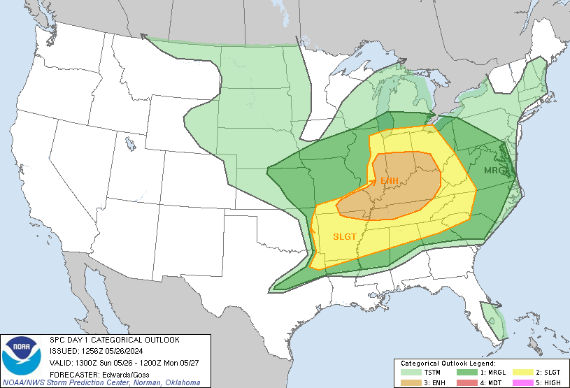
Forecast for May 26, 2011
Today:
Skies will be sunny through the daytime hours. We will have winds increasing a bit from the south as temperatures warm to near 90. The warm temperatures combined with high humidity will make it feel even warmer.
Tonight:
There is a chance we'll have a few scattered T'Storms develop this evening. Any that do could produce strong winds and large hail and for that reason we are under a slight risk for severe storms. Lows tonight will stay mild as we only cool off to near 70.
Friday through Memorial Day:
T'Storms are possible both Friday and Saturday but we'll stay mainly dry through Monday. Temperatures will range from the low to mid 80s Saturday all the way to the low 90s by Monday. It will be a great Memorial Day for the beach or a local pool!
Flier:

Forecast for May 25, 2011
Today:
Skies today will be mainly sunny and we'll have dry conditions, at least through the daytime hours. Highs today will top into the mid to upper 80s with winds turning to the south. The latest severe threat from the SPC is seen below:
Tonight:
As has been the past couple of nights, tonight there will be a chance for some showers and thunderstorms, but not all areas will receive them. Lows will be into the upper 60s.
Thursday through Sunday:
Another round of afternoon/evening showers and storms are possible on Thursday, Friday, and Saturday with the best chance for widespread activity coming on Friday. Highs Thursday and Friday will top near 90. Saturday and Sunday we'll hit the upper 80s with slightly less humid conditions.
Flier:

Forecast for May 24, 2011
Today:
A light round of morning showers will exit the District and we'll be left with partly sunny conditions through much of the day. Redeveloping showers and thunderstorms are expected, especially late this afternoon and into the evening. Some of these storms could be severe and we are under a slight risk for severe weather from the Storm Prediction Center. Highs today will be in the upper 80s with light west winds.

Tonight:
It will stay muggy tonight as we only cool down to near 70 degrees. Chances for showers and storms will continue, but mainly just during the evening.
Wednesday through Saturday:
Wednesday will be mainly dry but an isolated thunderstorm can't be ruled out. Chances for more widespread thunderstorms move back in Thursday and stay with us through at least Saturday as our weather resembles more of a Miami like forecast than a DC one.
Flier:

A light round of morning showers will exit the District and we'll be left with partly sunny conditions through much of the day. Redeveloping showers and thunderstorms are expected, especially late this afternoon and into the evening. Some of these storms could be severe and we are under a slight risk for severe weather from the Storm Prediction Center. Highs today will be in the upper 80s with light west winds.
Tonight:
It will stay muggy tonight as we only cool down to near 70 degrees. Chances for showers and storms will continue, but mainly just during the evening.
Wednesday through Saturday:
Wednesday will be mainly dry but an isolated thunderstorm can't be ruled out. Chances for more widespread thunderstorms move back in Thursday and stay with us through at least Saturday as our weather resembles more of a Miami like forecast than a DC one.
Flier:

Forecast for May 23, 2011
Today:
Skies will be partly cloudy for most of the day but chances for showers and thunderstorms will increase as we move into the later afternoon hours. Highs will be in the mid to upper 80s. Winds will be from the south at 5-15 mph.
Tonight:
Chances for thunderstorms will continue during the evening but wane during the overnight ours as instability decreases with the sunset. Lows will be in the mid to upper 60s with winds coming from the southwest at 5-10 mph.
Tuesday through Friday:
Our forecast will be like one you would see in Miami or the tropics. Chances for showers and thunderstorms will exist each and every day but the majority of the time we will be dry. It will be warm and humid with highs staying in the mid to upper 80s and dew points ranging from the low to mid 60s.
Forecast for May 19, 2011
Today:
The Upper Level low that has been giving forecasters headaches all week will finally shift off to the north and east. It'll still bring in more showers and thunderstorms through our area but we'll slowly head towards improving conditions. Highs today will be in the low to mid 70s with light N winds.
Tonight:
Showers and thunderstorms will continue to stay in the forecast but mainly just during the evening hours. Lows will be in the upper 50s with winds slowly turning to the west.
Friday through Monday:
A few showers are possible, mainly early on Friday, and then we'll break out into some sunshine. Temperatures will be in the 80s on Saturday and Sunday with dry conditions. We look to stay in a mainly dry weather pattern as we enter next week too.
Flier:

Forecast for May 18, 2011
Today:
We'll have close to a repeat of Tuesday today. Anticipate periods of showers and thunderstorms with breaks in between as the upper level low remains to our southwest. Highs today will reach the low to mid 70s with light east winds.
Tonight:
Periods of showers and thunderstorms will continue tonight with cloudy skies. We'll drop down to a low near 60 with winds light out of the southeast.
Thursday through Sunday:
We'll slowly dry things up, but there will be some scattered showers and thunderstorms through Friday morning before skies finally start to break up some. Saturday and Sunday look dry with temperatures by the weekend climbing into the lower 80s.
Flier:

Forecast for May 17, 2011
Today:
The United States is locked into a blocking pattern this week. A blocking pattern is a formation of systems that keeps them from moving. Right now we are in an omega block and an upper level low will be keeping us with showers and storms for the next couple of days before the Omega Block finally breaks down. Highs will be in the low 70s with light east winds.
Tonight:
Periods of showers will continue across the entire Eastern Seaboard. Lows will only drop to near 60 due to the thick clouds and high levels of moisture that will be across DC.
Wednesday through Saturday:
Periods of Showers and Thunderstorms will continue on Wednesday before chances slowly diminish on Thursday. By Friday morning the rain should all be over but we'll have cloudy skies. Temperatures through the period will gradually warm back into the upper 70s. The sunshine looks to finally return by Saturday afternoon.
Flier:

Forecast for May 12, 2011
Today:
Another perfect 10 will be found across DC today. Winds will be from the south at 5-10 mph as temperatures climb into the middle to upper 70s.
Tonight:
A few clouds will filter in today and by Friday morning we'll have partly to mostly cloudy conditions. Lows will only cool off to near 60 with the added blanket and winds will be calm.
Friday through Monday:
Friday will be mainly dry for the area but a few spots may see some isolated showers. The best chance for rain Friday will come in the evening. Saturday and Sunday we'll have scattered showers and thunderstorms with the better thunderstorm chance coming Sunday. Temperatures through the period will remain in the low to mid 70s.
Flier:

Forecast for May 10, 2011
Today:
Sunshine will be plentiful again today as our weather will remain nearly the same as yesterday. The only real difference will be that we climb up a few degrees to the mid 70s.
Tonight:
It will be another superb evening with light and variable winds and temperatures cooling off into the mid 50s in the city and in the upper 40s through the suburbs.
Wednesday through Saturday:
The weather will stay gorgeous through the daytime hours on Friday, with temperatures staying mainly in the mid 70s through Saturday. A chance for showers and storms will move in Friday evening, but the best chance for widely scattered rain will be on Saturday.
Flier:

Forecast for May 9, 2011
Today:
Perfect, light north winds, sunshine, and high temperatures will be in the low 70s.
Tonight:
It will be a comfortable evening to start off the work week for the entire North Eastern region of the United States. Lows will be in the lower 50s in teh city and in the mid to upper 40s in the suburbs.
Tuesday Through Friday:
Our day's will be like a broken record to start off the week with temperatures slowly warming from the low to mid 70s to the upper 70s by Friday. Friday will be our next opportunity for widespread showers and thunderstorms.
Flier:

Forecast for May 5, 2011
Today:
For Cinco de Mayo we'll have plenty of sunshine with breezy and cool winds from the northwest. Highs today will be near 70.
Tonight:
Skies will remain clear tonight as the pressure gradient weakens and winds diminish. Lows will be in the lower 40s, meaning a jacket would be a wise idea if you're heading out to celebrate.
Friday through Monday:
Models are now flip flopping on rain chances for the weekend. While none of the days will be a washout, some showers should be anticipated across the Mid-Atlantic on Friday and Saturday with just a few lingering chances on Sunday. Temperatures will be in the low to mid 70s through the weekend.
Flier:

Forecast for May 4, 2011
Today:
Showers will come to an end by the midday hours with skies staying mainly gray skies through the day. An isolated shower is possible late this afternoon but shouldn't be something to cancel plans around. Temps today will remain steady near 60 degrees and winds will be a bit breezy at times out of the NW.
Tonight:
Skies will become clear this evening with winds staying from the Northwest. Lows will dip into the mid 40s in the city, and drop to near 40 in the suburbs.
Thursday through Sunday:
Thursday will be breezy but warmer than today as highs climb into the upper 60s. Friday we'll top near 70 with partly sunny skies and just a few afternoon showers. Saturday looks excellent with sunshine and highs again near 70. A better chance for rain moves into the area Saturday night into Sunday.
Flier:

Forecast for May 3, 2011
Today:
In advance of the next cold front temperatures will soar into the low to mid 80s today. Winds will be coming from the South at 5-15 mph underneath Partly Sunny skies.
Tonight:
Showers and storms will develop tonight. Some of the storms may become severe with hail and damaging winds being the main threat. As the front slides through winds will turn to the West at be a bit breezy at times.
Wednesday through Saturday:
Temps Wednesday will not rebound much from our overnight lows as a much cooler air mass controls our weather. Rain will be possible early Wednesday but end by the midday hours at the latest. Thursday will warm back to the mid 60s with Friday and Saturday looking near perfect with Partly Cloudy skies and highs near 70.
Flier:

Forecast for April 28, 2011
Today:
A Tornado Watch is in effect for the entire DC area until 3pm today. Storms should be past our area by that time but any moving through your area during the morning and early afternoon will be capable of brief spin up tornadoes. Highs today will be in the upper 70s with winds a bit breezy at times out of the South.
Tonight:
Skies will clear tonight and humidity levels will drop. Lows will be in the mid 50s with light West winds.
Friday through Monday:
Friday through Sunday will be pleasant with highs in the low to mid 70s and sunny skies. Monday we will bring in our next chance for showers and thunderstorms.
Flier:

Forecast for April 27, 2011
Today:
Another pleasantly warm day is in store for the Mid-Atlantic region. Highs will be near 80 with winds becoming breezy at times out of the South. A chance for thunderstorms will move in late in the afternoon but best chances will be in the evening.
Tonight:
The threat for some scattered strong thunderstorms will continue through the night as we drop to near 70. Winds will stay from the South at 5-15 mph.
Thursday through Sunday:
Thursday looks dreary with highs in the upper 70s. We'll have cloudy skies with showery conditions. Friday through Sunday look dry and comfortable with highs each day near 70!
Flier:

Forecast for April 26, 2011
Today:
Skies today will be mainly sunny early but a few puffy cumulus will develop in the afternoon. Isolated T'Storms are possible in the late afternoon hours as well. Winds will be from the South at 5-15 mph as highs climb to near 80.
Tonight:
A chance for isolated T'Storms will continue during the night underneath partly cloudy skies. Winds will stay from the South and be light as temps drop into the mid to upper 60s.
Wednesday through Saturday:
A threat from storms will move in Wednesday as well but the best chance for rain in the next five days will be Wednesday night into Thursday. Temps Wednesday will be near 80, and then cool off with highs near 70 the rest of the week.
Flier:

Forecast for April 14, 2011
Today:
Perfect: Highs near 70, light winds, and sunny skies: Perfect.
Tonight:
Skies will remain mostly clear tonight as temperatures drop to near 50 degrees. Winds will be light out of the north.
Friday through Monday:
Friday will be a little cooler but we'll stay dry. Friday night clouds will thicken as next system heads our way. We'll have periods of showers on Saturday and some of them will be heavy at times. After we make it through Saturday the extended period looks mainly dry and pleasant.
Flier:

Forecast for April 13, 2011
Today:
We'll start off today a bit wet, but anticipate dry conditions by the midday hours. Highs today will be in the low 60s with just a few peeks at the sun possible later in the afternoon. Winds will be a bit breezy at times out of the North Northwest.
Tonight:
Skies tonight will stay mainly gray but clear up as we move into Thursday morning. Winds will diminish out of the north with lows in the upper 40s.
Thursday through Sunday:
Thursday and Friday will be pleasant with highs near 70 and sunny skies as high pressure dominates. Friday night showers will move in and they'll stay with us through Saturday. Saturday and Sunday temperatures will be in the lower 60s.
Flier:

Forecast for April 12, 2011
Tuesday:
Unfortunately today will not be a repeat of yesterday. Anticipate periods of showers with mainly dreary weather staying put across the Mid-Atlantic. Temperatures will mainly remain steady through the day in the low to mid 60s. Winds will be light out of the East.
Tonight:
Showers will gradually taper off this evening as skies remain gray over us. Lows will be near 50 degrees with winds turning to the NW at 5-10 mph with the passage of the cold front.
Thursday:
Skies on Wednesday will be partly to mostly cloudy with highs in the low to mid 60s. The sun will return in abundance on Thursday with temperatures reaching the mid to upper 60s. Friday improvements will continue but we'll have a chance for developing thunderstorms. The greater chance for storms will be on Saturday before we see another cool down on Sunday.
Flier:

Forecast for April 11, 2011
Today:
We'll start off the day with some patchy fog but that will burn off and we'll be left with partly sunny skies. Highs will be way above normal, especially to our south. Highs in DC will be in the low to middle 80s with highs to our south approaching 90! Winds will be sustained at 5-15 mph out of the S, but will gust higher at times.
Tonight:
A line of thunderstorms will move through tomorrow night. If you are out enjoying the beautiful weather please make sure you keep an eye to the sky. Winds will turn to the NW at 5-15 mph as a cold front brings an end to our mild day.
Tuesday through Friday:
Temperatures Tuesday will be a bit cool for mid April, but otherwise temperatures will be fairly seasonable through the end of the work week. Friday currently looks like the warmest day outside of tomorrow, when we'll head back to near 70 degrees. The forecast does look dry for the work week as well, with the exception for an isolated shower Tuesday.
Flier:

Forecast for April 7, 2011
Today:
Skies today will be partly sunny to mostly cloudy, with above normal temperatures moving back in. Winds will be out of the WNW at 5-10 mph with high temperatures reaching the upper 60s to near 70 degrees in the District.
Tonight:
Skies tonight will be cloudy as temperatures cool into the upper 40s. Showers will be possible during the overnight but the best chance will hold off until after sunrise on Friday.
Friday through Monday:
Friday anticipate periods of showers during the day with a few showers possible in the evening. It will be much colder with highs only in the low 50s. Saturday a chance for a few showers will be possible with again temperatures staying cool. Sunday skies will show the sun a few times but we'll still have plenty of clouds. Highs will return to the low to mid 70s. Monday a chance for storms moves in with highs reaching the low to mid 80s!
Flier:

Forecast for April 6, 2011
Today:
Temperatures will return to seasonal averages as winds turn back to the southwest. High temperatures today will reach the low to mid 60s underneath partly sunny skies.
Tonight:
We'll continue to have partly to mostly cloudy skies through the nighttime hours. Low temperatures will not be nearly as cold with the partial blanket. We'll only cool off into the upper 40s.
Thursday through Sunday:
Temperatures will continue to warm on Thursday in advance of the next system set to move in Friday/Saturday. Highs Thursday will be in the upper 60s before dropping back to the 60 degree range for Friday and Saturday. Models continue to hint at a big warm up that will stick around for a few days next week.
Flier:

Forecast for April 5, 2011
Today:
Yesterday we tied record highs of 85 degrees at National and 84 at Baltimore and 83 at Dulles.
We'll start off today, much colder and with remnants of a squall line that will move east by the midday hours. It will be windy out of the west and temperatures will not rebound at all from our morning lows. Temperatures, in fact, will dip down into the low 50s by the early afternoon. We may see a peak of sunshine as we head towards evening but most of the day will be gray.
Tonight:
It'll be a chilly night with clear skies and temperatures knocking back into the upper 30s. Winds will diminish out of the West to 5-15 mph.
Wednesday through Saturday:
Wednesday through Saturday look seasonable temperature wise. On Wednesday and Thursday we'll have dry conditions with highs in the low to mid 60s. Friday and Saturday the seasonable temperatures will continue, but we'll have chances for rain showers as well. Next week we may have a big warm up with temperatures on Monday moving back into the 80s.
Flier:

Forecast for April 4, 2011
Today:
We'll have unseasonably warm temperatures today as some strong southerly winds usher in mild air. Highs will be in the mid to upper 70s across the Mid-Atlantic. Winds will be out of the S from 15-30 mph and they will gust above 30 at times.
Tonight:
It will stay breezy during the evening as temperatures will drop into the mid 50s. It will stay windy through the night. A cold front will move through during the overnight. We'll also have a chance for showers and thunderstorms with the best chance arriving late tomorrow night into Tuesday AM.
Tuesday through Friday:
The rain will exit Tuesday and winds will stay breezy but turn to the West. Temperatures will remain fairly steady through the day. Wednesday and Thursday look nice before another chance for showers moves back in Friday. Temperatures look to be more seasonable throughout the week. Average highs for us are now in the lower 60s.
Flier:

Forecast for March 31, 2011
Today:
This morning we'll have patchy drizzle with rain showers moving back in this afternoon. High temperatures will stay well below normal as we only reach the mid to upper 40s. Winds will be light out of the north.
Tonight:
Rain showers will continue off and on tonight with mainly gray skies. Low temperatures will be in the mid to upper 30s. A few flakes are possible once again but any accumulation is highly unlikely, with the only exception being for extreme northern suburbs.
Friday through Tuesday:
Friday a few showers will be possible early in the day, but the sun will come out during the afternoon with temperatures climbing back above 50! That is still about 10 degrees below our average high for early April. Saturday and Sunday both look dry with temperatures slowly warming into the middle 50s. Monday looks even better with a high back near 60. Chances for rain will move back in Monday and Tuesday as well.
Flier:

Forecast for March 30, 2011
Today:
The morning commute will be dry, but the Mid-Atlantic will have showers spreading from SE to NE during the midday hours. Winds through the day will be out of the ENE at 5-10 mph with highs only reaching the mid 40s.
Tonight:
Rain will continue off and on through the night with a chance for some snowflakes to mix in during the overnight hours as temperatures cool into the low to mid 30s. Any snow that does fall will not accumulate.
Thursday through Sunday:
Patchy drizzle will be found across our region to start off Thursday. It will eventually clear out before another round of rain moves in Thursday night. Again some mixing of snowflakes will be possible during the overnight. Friday the rain will taper off early and we'll then dry out for the weekend. Saturday and Sunday look fine with temperatures still below normal in the low to mid 50s.
Flier:

Forecast for March 29, 2011
Today:
Tuesday looks to be our best day of the next five. Skies will be mainly sunny with winds remaining light out of the North. Highs today will only be in the low 50s.
Tonight:
Clouds will be on the increase tonight as a short wave moves towards the Mid-Atlantic. Low temperatures will be in the upper 30s in the city and drop into the lower 30s across the suburbs. Winds will be light and variable.
Wednesday through Saturday:
We'll have several short waves moving through and bringing with them chances for precipitation. Precip will mainly fall in the form of rain but some snow flakes are possible during the night time hours of Wednesday and Thursday. Our best chances for precip will be Wednesday afternoon into Wednesday night and again on Thursday night. Friday chances for rain will continue but mainly just during the morning hours. Saturday skies still look partly to mostly cloudy but we will be dry.
Flier:

Forecast for March 28, 2011
Today:
Skies today will be a bit deceiving as they'll be mainly sunny. Winds will be light out of the North as temperatures struggle to climb into the upper 40s.
Tonight:
Temperatures this evening will drop back below freezing with clear skies and light north winds. In the District we'll drop to around 30, but in the suburbs we'll drop off into the low to mid 20s.
Tuesday through Friday:
Tuesday will be another dry, but cold day. Wednesday looks like a wet one with rain off and on during the daytime hours. Thursday and Friday we'll have chances for rain but neither day looks like a complete washout. The colder than average temperatures look to continue through at least the weekend.
Flier:

Forecast for March 24, 2011
Today:
Today will be crummy across the Eastern 2/3 of the United States as cold air was brought down by the front that moved through with the thunderstorms last night. Highs will only reach the upper 40s with breezy North winds. Skies will remain gray through much of the day as well.
Tonight:
Winds will diminish and skies will break up tonight. Temperatures will fall into the lower 30s.
Friday through Monday:
Friday will be dry but cold. Saturday and Sunday we'll have a chance for some rain showers with even a chance for snow Saturday night into Sunday morning. Monday during the day looks dry before another chance for precipitation moves in Monday night. The below normal temperatures will continue through at least the middle of next week.
Flier:

Forecast for March 23, 2011
Today:
Rain showers will be with us through the day with some showers and thunderstorms this afternoon. Some of the thunderstorms could be on the strong side, especially to the west of the DC Metropolitan area. Highs will be in the mid to upper 50s with winds coming from the East at 5-10 mph.
Tonight:
Showers will continue off and on through the night. They will taper off however as we head into Thursday morning. Winds will be out of the ENE at 5-15 mph as we drop off into the lower 40s.
Thursday through Weekend:
Thursday and Friday will both be dry but much colder than we have been for the past week. Highs temperatures will be lucky to climb above 50 degrees through early next week. Rain showers will move back in Saturday night and we'll continue to keep showers in the forecast on Sunday. While highly unlikely, even a couple snow flakes will be possible Saturday night if the system doesn't slide to our south.
Flier:

Forecast for March 22, 2011
Today:
Today will be the last semi-pleasant day before colder air starts moving back into the Mid-Atlantic. Highs will range from the low to mid 60s with partly sunny skies. Winds will be light out of the North.
Tonight:
Skies will be mainly gray during the evening with rain showers moving in during the overnight. Lows will dip into the mid 40s as winds turn to the East.
Wednesday through Saturday:
It will be an active and much cooler end to our work week. Wednesday showers will continue with highs only reaching the mid 50s. Thursday and Friday will be dry with highs in the low 50s and lows dropping into the 30s! Saturday will be even cooler with a chance for some rain showers as well.
Flier:

Forecast for March 17, 2011
St. Patrick's Day:
Skies today will be completely sunny as the Irish and everyone pretending to be Irish celebrate St. Patrick's Day. Temperatures will warm into the mid to upper 60s and winds will be fairly light out of the SW.
Tonight:
Patio weather will continue to be in effect through the evening as we cool down to only 50 degrees. Skies will be clear with winds turning a bit to the west.
Friday through Weekend:
Friday will be an excellent day with highs reaching the mid to upper 70s. A few spotty showers are possible Friday night into Saturday before another nice day moves in for Saturday afternoon. Temps Saturday will be in the mid 60s. Sunday a few clouds will move in with highs only reaching the mid 50s. Sunday night into Monday another chance for showers moves in, with temperatures staying seasonable in the long term (Mid to upper 50s).
Flier:

Forecast for March 16, 2011
Today:
Rain will end early today with high temperatures climbing to near 60 degrees. Skies will be mainly gray with a few peeks at the sun possible this afternoon.
Tonight:
Skies will become partly cloudy this evening as we cool off to near 40 degrees. Winds will be light out of the North and West.
St. Patrick's day through Weekend:
A ridge will build in and bring some mild temperatures for this time of year from Thursday through at least Saturday. Thursday highs will hit the upper 60s, Friday we'll hit the upper 70s, and temperatures will stay mild in the 60s on Saturday as well. Patio weather will be in full effect, making for a great weekend to be Irish.
Flier

March 15, 2011
Today:
Skies will be cloudy through the day with chances for rain showers moving in this afternoon. Temperatures will be in the lower 50s. Winds will be fairly light out of the ENE.
Tonight:
Lows will be in the low to mid 40s. It will be raining off and on through the night.
Wednesday through Sunday:
Rain will continue through rush hour Wednesday. Clearing skies will then take shape by late in the day and the warm up will commence. Highs Wednesday will reach the 60s, and we'll be in the mid to upper 60s for St. Patrick's day. Friday we'll hit the mid to upper 70s before cooling back into the mid to upper 60s Saturday. Enjoy the nice temps as Spring looks to permanently move in.
Flier:

Forecast for March 14, 2011
Today:
We'll start off the weekend by retreating a bit from how nice it was Saturday and Sunday. Highs today will be in the low 50s with skies staying mainly sunny. Winds will be from the N at 5-10 mph.
Tonight:
Clouds will filter in as our next weather maker heads our way. Lows will be in the upper 30s and winds will be light form the NE.
Tuesday through Friday:
Tuesday will be mainly cloudy through the daytime hours with showers starting to hit our area by the evening. Rain showers will continue early Wednesday before a big warm up moves in. Highs Thursday will be in the mid to upper 60s and Friday we'll be pushing close to 80! Looks like excellent Patio weather for the start to the weekend and St. Patrick's day.
Flier:

Forecast for March 11, 2011
Today:
We'll have much improved conditions today with dry weather across the Mid-Atlantic. Highs will be in the low to mid 50s with Partly Sunny skies. Winds will be out of the W at 5-10 mph.
Tonight:
Clearing conditions will continue as we drop into the low to mid 30s. Winds will be light out of the west.
Weekend into middle of next week:
Dry weather will be through the day into the middle of next week. Temperatures will bounce between the middle to upper 50s before warming into the low to mid 60s by the end of next week.
Flier:

Forecast for March 10, 2011
Today:
It will be tough to stay dry along the entire Eastern Seaboard today. Expect heavy rain across our area today with 2-3" possible from the storm. Winds will be a bit breezy at times out of the SE with temperatures warming into the upper 50s. Isolated T'Storms are also possible during the afternoon hours.
Tonight:
Rain will continue during the evening before tapering off as the front approaches us. Lows will be in the lower 40s with skies staying mainly cloudy. Winds will be from the S at 5-15 mph.
Friday through Monday:
We'll dry out Friday through the weekend with temperatures staying seasonable to just above normal. Friday winds will be a bit breezy at times out of the West. Temperatures will be in the low 50s Friday before warming to near 60 Saturday. Dry weather looks to continue into the middle of next week.
Flier:

Forecast for March 9, 2011
Today:
Skies will start off cloudy and winds will be fairly light out of the ESE. Chances for rain will move in late this afternoon with better chances coming after sunset. Highs will be in the upper 40s.
Tonight:
Periods of rain will happen through the night and it will fall heavy at times. Winds will also pick up and become breezy as a system inches closer to the Mid-Atlantic. Lows will not drop off much as we'll bottom out in the low to mid 40s.
Thursday through Sunday:
Thursday periods of heavy rain will continue at times with highs reaching the upper 50s. Friday we'll only top out in the low 50s but Saturday we'll hit near 60 with sunny skies. The dry and comfortable conditions will continue Sunday as well.
Flier:

Forecast for March 8, 2011
Today:
Sunshine will be in abundance today and winds will be light out of the east. Temperatures will be fairly seasonable with highs reaching the lower 50s.
Tonight:
A few clouds will filter in as winds stay out of the east. Lows will be in the lower 30s.
Wednesday through Saturday:
Clouds will filter in Wednesday as the next cold front approaches. Rain showers that will be heavy at times will move back in Wednesday night and continue off and on through the day on Thursday. Showers will taper off Thursday night and we'll dry out Friday and Saturday. Temperatures through the period will be in the low to mid 50s.
Flier:

Forecast for March 4, 2011
Today:
Skies today will start off Partly Cloudy but become Partly Sunny during the afternoon. High temperatures will not be as cold as they were today. We'll top out near 50 degrees. Winds will be a bit breezy at times out of the S.
Tonight:
Temperatures this evening won't drop much as we will be underneath gray skies. Winds will continue out of the S at 5-10 mph. Lows will be near 40.
Saturday through Tuesday:
Saturday skies will be cloudy with rain showers moving in during the late afternoon and evening hours. Rain showers will continue Sunday before tapering off Sunday night. Skies will then slowly clear out with pure sunshine returning Tuesday. Temperatures through the period will be in the upper 50s Saturday and then cool off into the low to mid 50s for Sunday - Tuesday.
Flier:

Subscribe to:
Posts (Atom)